- Shopping, made easy.
- /
- Get the app!

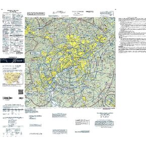
Anyone who will be flying VFR around the Valley of the Sun owes it to himself/herself to obtain a copy of the FAA's incredibly informative, full-color Phoenix Terminal Area Chart (TAC). Although Sectional Charts are superior for enroute navigation, TACs rule the air when it comes to aviating safely in congested, Class B airspace. TACs utilize a large (1:250,000; 3.43 nm per inch [1.35 nm per cm]) scale that allows them to depict additional landmarks, important altitudes, radio frequencies, and other noteworthy aeronautical data that's not feasible to include on sectionals. Additionally, the Phoenix TAC features a VFR Flyway Planning Chart on the reverse side, which presents flight paths and altitudes to help low, slow aviators steer clear of larger, faster air traffic.The Phoenix TAC provides a detailed portrayal of the Class Bravo airspace centered around the Phoenix Sky Harbor International Airport (PHX). As with all TAC publications, this chart is updated on a 6-month cycle. An intuitive, detail-rich resource to enhance your situational awareness and operational safety while piloting around The Valley.