- Shopping, made easy.
- /
- Get the app!
"A thaw has begun as North and South Korea try new steps in their awkward diplomatic waltz. In 2000, after 47 years of uneasy truce, North Korean leader Kim Jong Il and South Korean leader Kim Dae Jung convened an inter-Korean summit. They agreed to economic cooperation, cultural exchanges, and cross-border visits for relatives separated by the Demilitarized Zone (DMZ)."
Published in July 2003 as half of a two-map set with "The Forgotten War: Three Long Years in Korea," this illustrated map is a perfect snapshot in time, depicting the continuing conflict between North and South Korea.
This illustrated map of the two Koreas provides a wealth of information on the state of diplomatic relations between the two nations at the turn of the century. An inset showing military and nuclear capacities includes national spending on military forces, and an inset of population density and demographic differences paints an accurate image of the situation that persists to this day. Additional notes on the economy, population, and military add further detail.
This map is drawn in Polyconic projection, where the parallels are all non-concentric circular arcs except for the equator, which is straight.
This illustrated map is truly a unique conversation piece. A must-have for anyone interested in modern history.
Your laminated map has a glossy finish so that you can use dry erase markers on the map to highlight features, make plans, and share unique information with others. Lamination is also extremely durable, resistant to folding or ripping.
Your map is rolled and packaged in a sturdy tube to protect it during shipment.
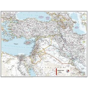 National Geographic Maps: Middle East Wall Map - Compact - 21.5 x 16.25 inches - Front Lamination
KWD 6.500
National Geographic Maps: Middle East Wall Map - Compact - 21.5 x 16.25 inches - Front Lamination
KWD 6.500
 -6%
National Geographic: Peoples of Africa 1971 - Historic Wall Map Series - 24.5 x 22.5 - Laminated
KWD 16.500
-6%
National Geographic: Peoples of Africa 1971 - Historic Wall Map Series - 24.5 x 22.5 - Laminated
KWD 16.500
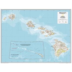 National Geographic Maps: Hawai'i Wall Map - Compact - 21 x 16 inches - Front Lamination
KWD 11
National Geographic Maps: Hawai'i Wall Map - Compact - 21 x 16 inches - Front Lamination
KWD 11
 -20%
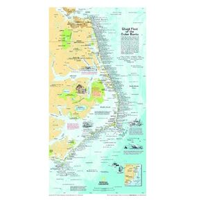
National Geographic: Ghost Fleet of the Outer Banks 1970 Map - Historic Wall Map Series - 11.75 x 21.25 inches - Rolled Canvas
KWD 16.500
-20%
National Geographic: Ghost Fleet of the Outer Banks 1970 Map - Historic Wall Map Series - 11.75 x 21.25 inches - Rolled Canvas
KWD 16.500


