- Shopping, made easy.
- /
- Get the app!
Combo of Military UTM/MGRS Coordinate Scale Map Reading and Land Navigation Topographical Map Scale, Protractor and Grid Coordinate Reader Pairs with Compass & Stencil with Military Marking Symbols For use with UTM, MGRS, USNG or other metric based coordinate systems. For use on maps with scales of: 1:25000 1:50000 1:100000 1:250000 Extensively used by NATO military forces and navigators to mark the map being measured Orange colored and transparent plastic made stencils allowing marking on paper sheets or clothes
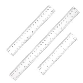 3 Pack Plastic Ruler Straight Ruler with Centimeters and Inches, Plastic Measuring Tool for Student School Office Drafting Tools (Clear, 6 Inch, 8 Inch, 12 Inch)
KWD 2
3 Pack Plastic Ruler Straight Ruler with Centimeters and Inches, Plastic Measuring Tool for Student School Office Drafting Tools (Clear, 6 Inch, 8 Inch, 12 Inch)
KWD 2
 Xiahuyu Thank You Gift for Speech Language Pathologist Speech Therapist Gift Keychain Speech Therapy Gift Speech Teacher Gift
KWD 2.500
Xiahuyu Thank You Gift for Speech Language Pathologist Speech Therapist Gift Keychain Speech Therapy Gift Speech Teacher Gift
KWD 2.500
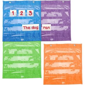 EAI Education Magnetic Connecting Pocket Charts - Set of 4
KWD 5.500
EAI Education Magnetic Connecting Pocket Charts - Set of 4
KWD 5.500
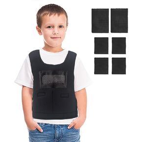 Weighted Vest for Kids with Sensory Issues, Kids Calming Weighted Compression Vest for Children - Include 6 Removable Weights
KWD 16.500
Weighted Vest for Kids with Sensory Issues, Kids Calming Weighted Compression Vest for Children - Include 6 Removable Weights
KWD 16.500


