- Shopping, made easy.
- /
- Get the app!
A very attractive example of the 1860 U.S. Coast Survey triangulation chart or map of southern Florida and the Florida Keys. Covers from Key Biscayne Bay south along the Keys, past Key West, as far as the Marquesas Keys. Countless triangulation points are noted throughout. Names each of the Keys and identifies Miami at the northern edge of Key Biscayne Bay, and the city of Key West, at the time a prosperous center of commerce. The chart was produced in, 1860 under the supervision of A. D. Bache, one of the most influential and prolific Superintendents of the U.S. Coast Survey.
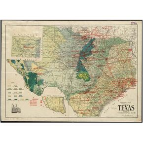 1917 Map of Texas oil and geological map | Shows oil fields, gas fields, pipelines | Ready to Frame | Size: 18x24 inches
KWD 14.500
1917 Map of Texas oil and geological map | Shows oil fields, gas fields, pipelines | Ready to Frame | Size: 18x24 inches
KWD 14.500
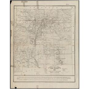 1890 Map New Mexico Official of New Mexico Shows settlements, townships, Land Grants, Indian reserva|Vintage Fine Art Reproduction|Ready to Frame
KWD 14.500
1890 Map New Mexico Official of New Mexico Shows settlements, townships, Land Grants, Indian reserva|Vintage Fine Art Reproduction|Ready to Frame
KWD 14.500
 10PCS Hall Passes for Classrooms Bathroom Passes for Classrooms Restroom Pass Classroom Passes with lanyards Unisex Restroom Pass Suitable for Office, Restaurant, Gas Station
KWD 4
10PCS Hall Passes for Classrooms Bathroom Passes for Classrooms Restroom Pass Classroom Passes with lanyards Unisex Restroom Pass Suitable for Office, Restaurant, Gas Station
KWD 4
 -8%
BAZIC Primary School Kit Supply Box 57 Count for Kindergarten Elementary Student K-6 Grades, Composition Book Coloring Pencil, Color May Vary, 1-Pack
KWD 16.500
-8%
BAZIC Primary School Kit Supply Box 57 Count for Kindergarten Elementary Student K-6 Grades, Composition Book Coloring Pencil, Color May Vary, 1-Pack
KWD 16.500

