- Shopping, made easy.
- /
- Get the app!

Laminated wall map of the Pittsburgh Metro Area showing locations within 35 - 60 miles of downtown Pittsburgh, including all of southwestern Pennsylvania. The map covers Allegheny, Lawrence, Butler, Armstrong, Indiana, Westmoreland, Fayette, Washington, Greene, and Butler Counties, as well as the immediate adjacent areas of Pennsylvania, West Virginia, Ohio, and Maryland. Features shown include cities, towns, major roads and highways, and zip codes. An index of community names is included. The laminated map is rolled and shipped in a tube.
 -8%
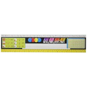
Desk Toppers® Reference Name Plates: Grades 3-5 (Zaner-Bloser)
KWD 5.500
-8%
Desk Toppers® Reference Name Plates: Grades 3-5 (Zaner-Bloser)
KWD 5.500
 Modern, Satin, Aluminum, Conference Room Slider Nameplate Holder, 8" x 2"
KWD 16
Modern, Satin, Aluminum, Conference Room Slider Nameplate Holder, 8" x 2"
KWD 16
 National Geographic: Mexico Executive Wall Map - Antique Style - 34.5 x 22.75 inches - Art Quality Print
KWD 23.500
National Geographic: Mexico Executive Wall Map - Antique Style - 34.5 x 22.75 inches - Art Quality Print
KWD 23.500
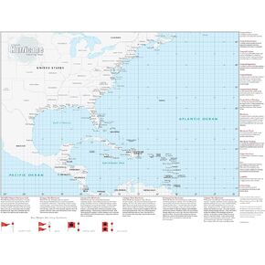 Hurricane Tracking Wall Map - 33" x 44" Laminated
KWD 35
Hurricane Tracking Wall Map - 33" x 44" Laminated
KWD 35