All electronics ship with US style plugs.You may need a voltage converter or a plug adapter.
Special Features
High-Accuracy GNSS Land Measurement: This handheld GPS for surveying delivers professional-grade precision with ±1% error for large areas (2,000+ sqm) and ±2m positioning accuracy (HDOP <1.0). Perfect for land surveyors, farmers, and outdoor enthusiasts, it supports six-star satellite positioning (GNSS/GPS) and multiple modes: Normal, Mountain, Fixed-Width, and Intelligent Slope Measurement. A must-have land surveying tool for property mapping, agriculture, and hiking navigation.
Real-Time Graphics & Smart Data Management: Instantly visualize land boundaries with live measurement graphics—no guesswork! Store 200+ area/distance records and export data via USB. Ideal for GPS land surveying, this handheld volume measuring instrument ensures efficiency for construction crews, foresters, and geocachers. Never lose critical land meter measurements again!
Auto Slope & Mountain Compensation: Skip manual calculations! This GNSS GPS device features Intelligent Slope and Mountain Modes to auto-adjust measurements on rugged terrain. Whether you're mapping hillsides, farms, or trails, it eliminates errors—making it the most reliable surveying GPS for uneven landscapes.
Ultra-Durable & Portable Design: Built for fieldwork with IP65 waterproof/dustproof protection and a 18-hour battery life. At just 112g, this compact handheld GPS unit fits in any pocket. The bright yellow casing ensures visibility in low light, while the barometer, altimeter, and flashlight add utility for hiking GPS adventures or remote land surveys.
All-in-One Surveying Solution: Beyond land area measurement, use it for distance tracking (slope/fixed-point), machine load calculations, and boundary marking. Combines GPS surveying equipment precision with user-friendly features like data export and real-time updates. The ultimate handheld GNSS land meter for professionals and outdoor explorers!


 -20%
SkyCaddie LX5, GPS Golf Watch with Touchscreen Display and HD Color CourseView Maps, Black, Small
KWD 75.500
-20%
SkyCaddie LX5, GPS Golf Watch with Touchscreen Display and HD Color CourseView Maps, Black, Small
KWD 75.500
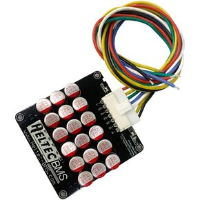 Heltec 4S 5S 6S 5A Capacitor Active Equalizer Balancer Lifepo4 Lithium Lipo/Titanate LTO for Battery Car Audio Group Balancer
KWD 20
Heltec 4S 5S 6S 5A Capacitor Active Equalizer Balancer Lifepo4 Lithium Lipo/Titanate LTO for Battery Car Audio Group Balancer
KWD 20
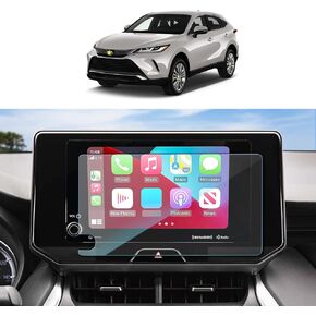 for 2023 2024 Toyota Venza Screen Protector for 2023 2024 Toyota Venza XLE/Nightshade Edition/Limited 12.3 Inch Navigation Display Toyota Venza 2023 2024 Accessories Tempered Glass 9H Hardness HD
KWD 3
for 2023 2024 Toyota Venza Screen Protector for 2023 2024 Toyota Venza XLE/Nightshade Edition/Limited 12.3 Inch Navigation Display Toyota Venza 2023 2024 Accessories Tempered Glass 9H Hardness HD
KWD 3
 TAKEWELL Bicycle Saddle Seat-Post Mount for Garmin Varia Rear View Radar Light,Compatible for RTL500, RTL510, RTL515, RVR315,Very Solid,Aluminum Alloy
KWD 7
TAKEWELL Bicycle Saddle Seat-Post Mount for Garmin Varia Rear View Radar Light,Compatible for RTL500, RTL510, RTL515, RVR315,Very Solid,Aluminum Alloy
KWD 7


