- Shopping, made easy.
- /
- Get the app!
FLAT 2D SHADED RELIEF MAP - Our Appalachian Trail 1981 Shaded Relief Map was created with shaded relief added to create the illusion of 3D by applying Digital Elevation Data and meticulously adding shaded relief to the landscape of the original 1981 Appalachian Trail map. The result is a stunning 3D illusion that showcases every detail of the trail's varied terrain. This unique map is designed and printed at the highest level to transport you to the heart of the Appalachian Trail. The printed on shading allows for traditional framing. The text on the map may be difficult to read due to the small font size, and the age of the map. In areas where relief shading covers the text, the underlying text is illegible. Made in the USA, our Shaded Relief Maps are printed with archival paper and inks ensuring an intricately detailed, fade-free piece with amazing colors. Made of 100% Cotton, OBA-Free, Acid-Free these maps are printed on heavyweight 21.5 mil fine art paper. At Muir Way, we consider our maps to be works of art, so we print them accordingly. Using top-of-the line printers with gallery quality fine art paper and inks, our maps will exceed expectations and last a lifetime. Here at Muir Way, we design maps meant for walls, not just as art, but as reminders of the places we love most. Each map tells the unique story of a location, capturing its essence. We are committed to providing the utmost quality, design and value in every piece we create.
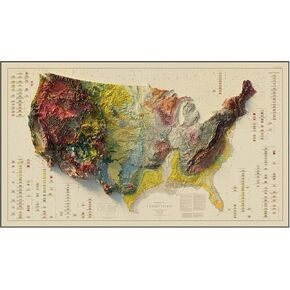 Muir Way - USA Geological 1932 Shaded Relief Map - Flat 2D Paper Print - Shaded 3D Illusion - Gallery Quality Fine Art Paper & Inks - 100% Cotton & Acid-Free - Made in USA -42" x 24"2D Print -No Frame
KWD 36.500
Muir Way - USA Geological 1932 Shaded Relief Map - Flat 2D Paper Print - Shaded 3D Illusion - Gallery Quality Fine Art Paper & Inks - 100% Cotton & Acid-Free - Made in USA -42" x 24"2D Print -No Frame
KWD 36.500
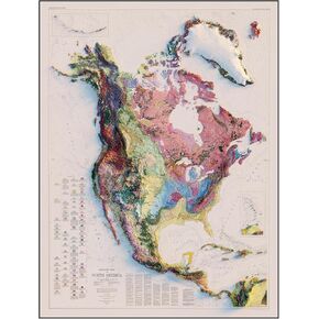 Muir Way - North America 1965 Shaded Relief Map - Flat 2D Paper Print - Shaded 3D Illusion - Gallery Quality Fine Art Paper & Inks - 100% Cotton & Acid-Free - Made in USA -24" x 32" 2D Print -No Frame
KWD 43.500
Muir Way - North America 1965 Shaded Relief Map - Flat 2D Paper Print - Shaded 3D Illusion - Gallery Quality Fine Art Paper & Inks - 100% Cotton & Acid-Free - Made in USA -24" x 32" 2D Print -No Frame
KWD 43.500
 48 Pieces Unique Sensory Stickers for Anxiety Relief Items - Sensory Strips with Storage Box - 2 Textured Surface Fidget Strips for Office & Classroom Desk - Relieve Adult & Teen Stress
KWD 4
48 Pieces Unique Sensory Stickers for Anxiety Relief Items - Sensory Strips with Storage Box - 2 Textured Surface Fidget Strips for Office & Classroom Desk - Relieve Adult & Teen Stress
KWD 4
 Muir Way Shaded Relief Elevation Map of USA - Vintage-Style Topographic Wall Art with 3D Map Look - Unframed Flat Paper Print, 24x37
KWD 49
Muir Way Shaded Relief Elevation Map of USA - Vintage-Style Topographic Wall Art with 3D Map Look - Unframed Flat Paper Print, 24x37
KWD 49


