- Shopping, made easy.
- /
- Get the app!
Laminated wall map of the Greater Detroit Metro area showing locations within 30 - 40 miles of downtown Detroit, including all of Wayne County, Oakland County, Macomb County and parts of Livingston, Washtenaw, Monroe, and Genesee Counties. Communities include Detroit, Dearborn, Ann Arbor, Warren, Royal Oak, Taylor, Pontiac, and Troy, among others. Features shown include cities, towns, major roads and highways, zip codes, and major points of interest. An index of community names is included. The laminated map is rolled and shipped in a tube.
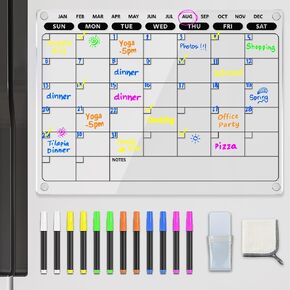 PigPotParty Acrylic Magnetic to Do List White Board for Refrigerator, 12"x9.5" Clear Dry Erase Board, Fridge Grocery List Magnet Checklist Whiteboard for Adult Family Kids, w/ 8 Markers and 1 Towel
KWD 6.500
PigPotParty Acrylic Magnetic to Do List White Board for Refrigerator, 12"x9.5" Clear Dry Erase Board, Fridge Grocery List Magnet Checklist Whiteboard for Adult Family Kids, w/ 8 Markers and 1 Towel
KWD 6.500
 ExcelMark 2" x 8" Custom Engraved Name Plate with Square Corners
KWD 4
ExcelMark 2" x 8" Custom Engraved Name Plate with Square Corners
KWD 4
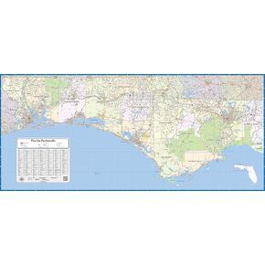 Florida Panhandle Laminated Wall Map (48 inch Wide by 22 inch high)
KWD 62.500
Florida Panhandle Laminated Wall Map (48 inch Wide by 22 inch high)
KWD 62.500
 -11%
Learning Resources MathLink Cubes - Set of 100 Cubes, Ages 5+ Kindergarten, STEM Activities, Math Manipulatives, Homeschool Supplies, Teacher Supplies
KWD 4
-11%
Learning Resources MathLink Cubes - Set of 100 Cubes, Ages 5+ Kindergarten, STEM Activities, Math Manipulatives, Homeschool Supplies, Teacher Supplies
KWD 4


