- Shopping, made easy.
- /
- Get the app!

Unique, color banded, this political LARGE PRINT map of Arizona state features geographic details. The map shows all county boundaries, county names with their capitals. Perfect for Schools, Home, Office or Home Schooling. - Large Print for easy reading - Counties with banded boundaries - All counties and their capitals - Major cities, selection of parks, monuments - Major Limited Access Highways - Major Geographical features - Size 24"W x 30"H(paper or laminated) - MADE in USA / PRINTED in USA
 Tassel Depot Graduation Honor Cord - Lilac - Every School Color Available - Made in USA
KWD 3
Tassel Depot Graduation Honor Cord - Lilac - Every School Color Available - Made in USA
KWD 3
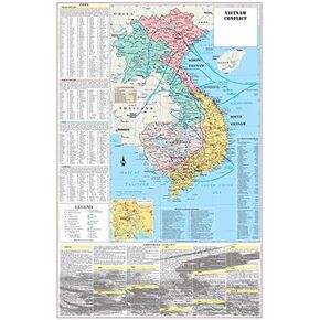 Cool Owl Maps Vietnam War Conflict Wall Map Poster Military - 24"x36" Laminated
KWD 10.500
Cool Owl Maps Vietnam War Conflict Wall Map Poster Military - 24"x36" Laminated
KWD 10.500
 TIME X Magic Grooved Writing Practice Books, Reusable Handwriting Practice Books, Groove Workbooks, Handwriting Practice for Kids 3 +, Large Writing Practice Books (Practice 6-Books)
KWD 15.500
TIME X Magic Grooved Writing Practice Books, Reusable Handwriting Practice Books, Groove Workbooks, Handwriting Practice for Kids 3 +, Large Writing Practice Books (Practice 6-Books)
KWD 15.500
 Magnetic Reward Jar, Personalized Smiley Tokens Reward Jar for Kids, DIY, Reward Jar, Classroom Management Tool, Reward Jars for Kids Magnetic, Back to School Gift for Kids
KWD 8.500
Magnetic Reward Jar, Personalized Smiley Tokens Reward Jar for Kids, DIY, Reward Jar, Classroom Management Tool, Reward Jars for Kids Magnetic, Back to School Gift for Kids
KWD 8.500